Address Lookup tools in Greenville County let residents quickly find property tax details, ownership history, and parcel numbers using a simple street address search. By entering a ZIP code or owner name, the address database returns public address records, legal descriptions, and map-based GIS visuals. This fast address search answers how to search for a property by address and helps verify a property location without leaving home.
The portal also supports address lookup by parcel number, city, or partial address when new subdivisions appear. Users can view property boundaries, neighboring lots, and assessed values on an interactive map, making it easy to confirm tax status or locate a recently assigned address. FAQs cover why an address might not be found and steps to correct missing or outdated information, ensuring reliable results for every search.
How to Search Address Lookup
Address Lookup in Greenville County begins with the county’s official real property record search. A street address, owner name, parcel number, city, ZIP code, or partial address can lead to a property record with tax, ownership, legal-description, and GIS details. You can also visit greenville county sc for broader county resources. Comparing those fields helps you verify a property location and find the identifiers used by other county records. A tax record alone does not settle a title question or establish a surveyed boundary.
Official Search Portal: https://greenvillecountysc.gov/disclaimer/PublicRecords.aspx?DirURL=RealProperty
Steps to Search
- Open the official county link and follow any records disclaimer shown before reaching the search page. If the page asks you to accept terms or continue, read the statement and select the on-page control that opens the real property search.
- Choose the search type that matches the identifier you have. Use a street address for property address lookup, an owner name for an ownership-based search, a parcel number for a direct parcel search, or a map view for a property location search. City, ZIP code, and partial-address fields can narrow the results or produce more candidates.
- Enter the street number and street name first when using an address. Add the city or ZIP code to reduce false matches. For a partial address, use the longest confirmed part, such as a street name paired with a city or ZIP code. Include a unit designator only when a source record shows one.
- Submit the search and compare the candidate rows instead of accepting the first result with a similar spelling. Check the parcel number, tax account number, owner name, and legal description against a tax bill, deed reference, or other property document when one is available.
- Open the matching property record and copy each identifier exactly as shown. A parcel number, parcel ID, and tax account number can appear in different places and may serve different record functions. Record the property type, lot and block entries, assessed data, tax year, and payment status displayed on the county page.
- Follow any official links for ownership history, recorded deeds, tax records, or GIS mapping. Confirm that each linked page carries the same parcel number or tax account number. A map result and an assessment result should point to the same parcel before you treat them as one property.
- Read the date and tax year beside each value and payment status. Use the county’s current tax record for payment questions because an older assessment page may show an earlier balance. Save the identifiers and page date if another office or professional must trace the same parcel.
Property Details Included in Address Records
A Greenville County address record connects several kinds of property details with identifiers assigned to a parcel and tax account. The assessment record, deed references, and GIS layer serve different purposes, so read each field label before copying a value. Parcel number, parcel ID, and tax account number may appear in separate records and should not be treated as interchangeable.
Current Owner and Owner Mailing Address
The ownership section can show the current owner name and an owner mailing address used for county records. That mailing address may differ from the situs address, which identifies the physical property location. Recorded ownership history and transfer dates belong with deed records, which offer a separate check on the name shown for tax purposes.
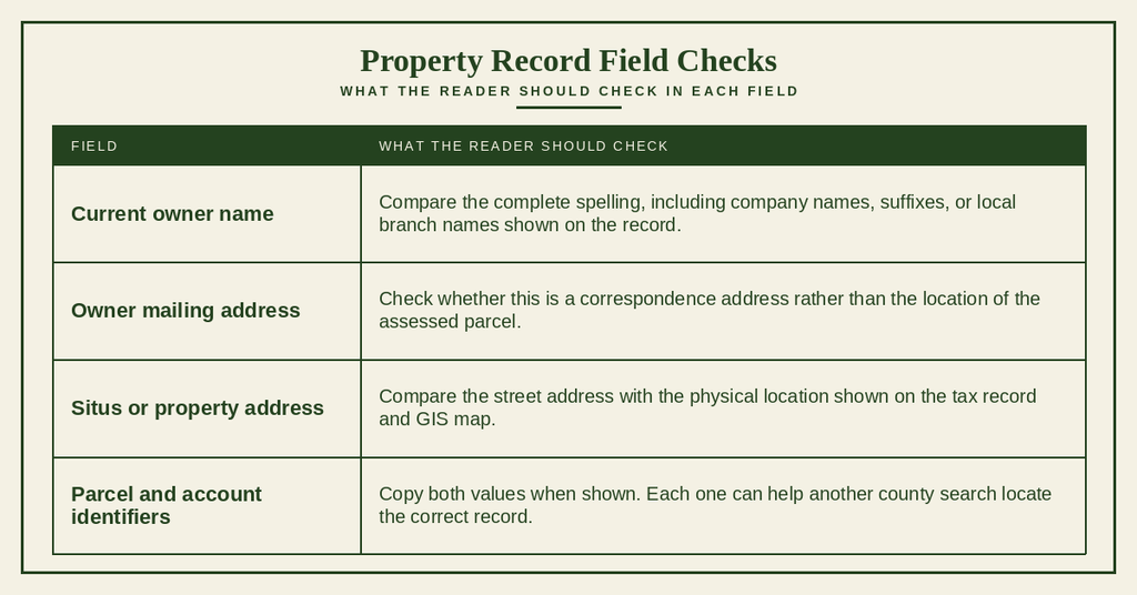
Owner names may include a personal suffix, a company name, or a local office name. Search with the fullest version shown on a tax or deed source, then compare the parcel identifier before treating two similar names as one owner.
Land, Building, and Structural Characteristics
Land and building fields describe how the county record classifies a parcel and its recorded improvements. Depending on the property, the page may list property type, classification, lot number, block number, land data, building data, and a legal description. Exact labels can differ by record, so copy the fields presented for that parcel instead of expecting every property to have the same entries.
Property assessment records may show the property type, classification, lot and block numbers, land acreage, and building details. The legal description helps identify the land covered by the tax parcel and should be checked alongside the parcel number. These fields describe recorded assessment information but do not independently confirm current occupancy, zoning, or property use.
A legal description can contain lot and block wording, a recorded plat reference, or a measured boundary description. Read it beside the parcel number because one street address can cover different recorded lots or separate tax accounts.
Property Assessment Values and Tax Status
Assessment and tax fields answer different questions. A record may show an assessed value, appraised value, taxable value, tax amount, tax account, tax year, and payment status. These labels can represent separate parts of the county’s assessment and collection process, so copy the stated amount rather than treating every value as the same figure.
Verify the tax account number against the parcel number and property address. Check the tax year and the exact labels for assessed, appraised, and taxable values, as these figures may represent different amounts.
Review the current county tax record for the tax amount, installment, due date, payment status, and any delinquency notice. Use the information shown for the correct account and tax year rather than relying on older property pages or estimating replacement figures.
Read the tax year beside every amount and status. A balance shown with an older tax year does not prove that the account is currently delinquent, and a current installment can differ from an annual total. For payment questions, open the county’s current tax record and compare the account number.
Recorded Deeds, Titles, and Historical Transfers
Recorded deeds document property transfers and can show prior owners, transfer dates, grantors, grantees, and a deed reference. Start with the parcel identifier so a deed for a similar street address is not mixed with another property. A public record summary may not contain every filing needed for a full title review.
- Note the deed reference, transfer date, and names shown for the parcel. Keep these beside the parcel number from the assessment record.
- Compare the deed legal description with the tax record. A matching street name alone is weaker evidence than a matching parcel and description.
- Follow available transfer references in date order. Each entry can connect an earlier owner or grantee to a later transfer record.
- Compare owner mailing addresses with property locations. A deed or tax record may use a correspondence address that differs from the parcel itself.
- Check whether the displayed history is a summary or a complete chain. Later instruments, liens, and legal claims may require a separate title review.
Historical property records may list previous owners without showing every recorded transfer. If the question concerns ownership claims, liens, or marketable title, ask a South Carolina attorney to review the complete recorded instruments and related filings.
Interactive Parcel Mapping and GIS Search
The GIS layer places a property in space rather than listing account fields alone. It can show an address point, parcel polygon, parcel boundaries, road frontage, and surrounding parcels. These map features help verify location and parcel scope, but they do not replace a recorded legal description, boundary survey, or title review.
Viewing Property Boundaries and Parcel Lines
Parcel lines are the mapped edges used by county GIS to show the shape and extent of a tax parcel. A mapped line can differ from a recorded boundary description, a flood boundary, a street edge, or another county layer. Read the map at a useful scale and check the selected parcel’s identifier before drawing conclusions.
- Select the parcel polygon or open its property record from the map.
- Read the parcel number, account number, owner name, and address shown in the map panel.
- Change the map scale to view corners, road frontage, and nearby access points without losing the parcel label.
- Compare the polygon with the legal description and any recorded plat reference supplied for the property.
Use mapped boundaries for orientation and parcel identification. A licensed surveyor must measure a disputed or precise boundary because a county GIS line is not a boundary survey.
Identifying Neighboring Properties and Surrounding Parcels
Selecting a surrounding parcel can reveal its address point, owner record, classification, and relationship to the target property. Shared map edges can help you see which parcels appear next to one another and which roads or waterways run between them. A neighboring record does not prove ownership of the target parcel.
Map Based Geographic Address Search
Map-based geographic address search is useful when a typed street address produces no match or too many candidates. A map search can place you near the correct road, subdivision, or parcel without relying on a misspelled owner name. It can also reveal whether the mapped point and tax parcel appear to describe the same location.
- Open the county GIS or map-linked search from the official property portal.
- Narrow the map to the city, ZIP code, subdivision, or nearby intersection shown in your source material.
- Select an address point or parcel polygon rather than judging the location from map imagery alone.
- Compare the selected parcel number, owner name, account number, and legal description with the assessment record.
Search Options by Property Type
Property-type records use several core identifiers, yet the most useful search clue can change by use. You can also explore case lookup through available county records. Residential accounts may center on a unit or subdivision lot, commercial accounts may cover a building or larger parcel, and land records may depend more heavily on parcel or owner fields. Check recorded classification rather than guessing from the property’s present use.
Residential and Multifamily Properties
Start a residential property search with the complete street address, ZIP code, and parcel number when available. Condominiums, townhouses, duplexes, and apartment communities can add unit or account data that does not appear on a basic street search. Read each account label before assuming that a building and a dwelling unit share one parcel number.
For detached homes and duplexes, search by street address or parcel number, then compare ownership, lot, land, and building details. For condominiums and townhouses, include the unit number and check whether a separate unit identifier is used. For apartments and multifamily properties, search by street address, parcel, or account number to determine whether the record covers the entire property or an individual unit.
A unit designator belongs in the search only when it appears on a reliable property source. Omitting it can return a building-level account, while adding the wrong unit can produce no match. Compare the returned legal description with the unit or lot shown on the source document.
Commercial and Industrial Buildings
A commercial or industrial search can begin with an exact street address, parcel number, or owner name. A business name may identify an occupant rather than the property owner, so do not use it as proof of ownership. Storefront, office, and owner mailing addresses can also differ from the assessed parcel location.
Verify the full street address and suite number against the correct tax account. Compare the parcel number, map boundaries, legal description, and account number to confirm the property. Check the complete owner name and recorded land or building classification. Use the legal description to distinguish the property from nearby parcels, and remember that an assessment category does not determine zoning.
A business directory or map listing may show a tenant, store name, or mailing location rather than the deed owner. Open the county ownership and tax records before using a commercial search result in a property transaction.
Agricultural Land and Vacant Lots
For agricultural land or a vacant lot, a parcel number can offer a more precise search than a street address when buildings are absent. Compare the owner, legal description, land classification, and GIS polygon. The assessment category provides recorded context, but it does not prove how the land is being used at the moment you view it.
For agricultural parcels, compare the owner name, parcel number, tax account, land classification, and full legal description. For vacant lots, check the street address, lot and block details, parcel boundaries, and any available building information.
For larger tracts or split and combined parcels, review the complete legal description, current parcel number, map boundaries, and deed history. Do not rely on the street address alone to identify the correct property.
A missing building field does not by itself settle the current condition of a parcel. Check the map, recorded description, and current county record before drawing a conclusion about access, structures, or land use.
Record Accuracy and Search Troubleshooting
A failed address search can result from spelling, unit format, parcel assignment, owner-name differences, or record timing. Work from the strongest identifier available: parcel number or tax account number, then full address, then owner plus city or ZIP code, and finally a partial map search. Keep the source document nearby so each fallback can be checked against the same parcel.
Resolving Incorrect Street Names or Missing Details
An address search can miss a record when a street type, directional prefix, spacing format, or unit label differs between sources. A mailing address can also cause confusion when the physical property uses another address. Correct the search fields one at a time instead of combining details from unrelated records.
- Copy the street number, street name, street type, directional prefix, city, ZIP code, and unit designator from the most authoritative source available.
- Search by city or ZIP code with the confirmed street name. This reduces false matches when several municipalities use similar street names.
- Compare the owner name and situs address on each candidate. Do not substitute the owner mailing address for the property location.
- Use a parcel number or tax account number from a tax bill, deed, recorded plat, or assessment source if the street search fails.
- Compare the legal description for each candidate. A matching owner or street name alone may point to a different parcel.
- Keep unit searches separate from street-level searches until the correct account structure is clear.
Do not combine a unit number from one property with a parcel number from another. If two sources disagree, carry both sets of identifiers into the next search and ask the county which entry can be traced to a recorded parcel.
Recently Assigned Addresses and New Subdivisions
New construction and new subdivisions can create a gap between street addressing, parcel creation, and tax setup. A mapped address may appear before a searchable tax account, or an assessor parcel may appear before an address search links to it. Do not assume a nightly, weekly, or monthly update cycle unless the live county portal states one.
- Search the new street on the GIS map and look for an address point or parcel polygon near the physical location.
- Use a parcel number or tax account number from a recorded plat, tax source, closing document, or other official property record.
- Compare nearby established addresses to check street spelling, directional terms, and subdivision boundaries.
- Contact the county with the subdivision name, map location, owner name, and any parcel identifier already available.
If the map and tax search show different identifiers, keep both entries until their relationship is clear. A new address, parcel number, and owner name may enter the searchable records at different times, so a failed query does not prove that the land or property is absent.
Handling Properties with Multiple Addresses or Units
One street address can serve several units, buildings, tax accounts, or mapped parcels. A condo or commercial complex may also use separate identifiers for shared land and individual units. The correct record comes from matching the unit designator, parcel, account, owner, and legal description rather than relying on the street address alone.
A repeated address does not prove that the county holds duplicate property records. It may represent separate units, ownership accounts, building parcels, or mapped address points. The parcel number and legal description provide the clearest way to separate those records.
Actions When an Address Cannot Be Found
If an address cannot be found, work through the available official identifiers instead of repeating the same query with slight spelling changes. A parcel ID, tax account number, owner name, legal description, subdivision, and nearby address can give the county enough context to trace a mismatch. Record the source and date for each identifier you use.
- Return to the official Greenville County real property portal and complete the disclaimer process if requested.
- Search the confirmed street name with city or ZIP code. Remove punctuation or unit details only when testing a broader street-level query.
- Search the owner name with the correct city or ZIP code, using the fullest name shown on a county or recorded source.
- Search a parcel number or tax account number taken from a tax bill, deed, recorded plat, or property closing document.
- Open the map and inspect nearby address points and parcel polygons for a recent address, changed street name, or new subdivision.
- Compare the legal description, owner, and tax account for each candidate rather than selecting a result from address similarity alone.
- Use the county contact details below during posted office hours. Give staff the parcel ID, owner name, subdivision, nearby addresses, and any deed reference you have.
Ask for the parcel match or correction path that applies to the record you found. Record the date of the request and any case or request number supplied by the county. A correction request does not replace a title review or boundary survey, so use the proper legal or surveying process for those questions.
Contact Details
Use these Greenville County contact details during the posted office hours when a portal search cannot resolve an address, parcel, owner, or account mismatch. Have your source document and search identifiers ready before calling so staff can trace the correct property record.
Frequently Asked Questions
Find quick answers on using Greenville County’s address lookup tools, from basic searches to troubleshooting missing records.
How to start an address lookup in Greenville County?
Begin at the county’s real‑property portal. Enter the full street address, city, or ZIP code in the search box. The system returns a property record that includes the parcel number, owner name, tax status, and GIS coordinates. Review the details to confirm the property you need. If you only have part of an address, use the partial‑address option to see possible matches. For help, call the office at (864) 467‑7300 during business hours.
Can I search by parcel number instead of street address?
Yes. The portal accepts a parcel number or parcel ID as a direct query. Type the number exactly as it appears on any tax bill or deed, then submit. The result shows the same record set you would get from a street‑address search, including owner information, legal description, and tax data. This method is useful when the address has changed or when you have only the parcel identifier.
Where can I find property tax info using an address?
After locating the property record, look for the tax tab or section on the page. It lists the current tax account, year‑by‑year assessments, taxable value, and any outstanding balances. You can also download a PDF of the tax bill if needed. For questions about payment status or exemptions, contact the tax office at the listed phone number.
How to verify a property’s legal description online?
Open the property record and find the legal‑description field. It outlines the lot, block, and subdivision details used in official documents. Compare this text with the deed or any existing paperwork you have. If the description differs, note the parcel number and request a copy of the recorded deed from the county clerk’s office for confirmation.
Why might an address not appear in the public records?
Several reasons can cause a missing address. The property may be newly built and not yet entered into the system, or the address could have been recently renumbered. Errors in spelling or using an outdated street name also prevent matches. In some cases, the parcel is listed under a different address, such as a mailing address rather than the physical location. Try searching by parcel number or owner name if the street address fails.